Tignes Spirit
This is the only independent, British-owned ski and snowboard shop in the Espace Killy.
Discover the latest Tignes snow conditions
Tignes continues into March with the mountain looking very solid from the village right up to the glacier. Snow remains visible throughout the resort and the high terrain above Val Claret and Grande Motte is still carrying a deep winter base. With the busy holiday period now behind us the pistes feel slightly quieter and well maintained, while the wider Tignes Val d'Isere ski area continues to offer reliable conditions across its high altitude slopes.
Current snow depths are around 110 to 140 cm at resort level around 2100 metres, with between 230 and 300 cm reported on the upper slopes above 3000 metres around the Grande Motte glacier which rises to 3456 metres. A light snowfall of around 5 to 10 cm has recently refreshed the higher slopes which has improved the surface conditions across exposed areas while the deeper snowpack remains well established.
Temperatures have ranged from minus 13 to minus 7 degrees on the upper mountain and between minus 5 and minus 1 degree in the villages depending on sunshine. The freezing level has generally stayed between 1500 and 1900 metres during the day and drops overnight which helps maintain excellent piste quality after grooming. Winds have occasionally been moderate near the highest ridges but overall conditions across the ski area have remained stable.
On piste, the best conditions are found above 2300 metres where the snow remains firm and grippy throughout most of the day. The glacier sector and the open slopes above Val Claret are holding particularly well and offer consistent skiing from morning through the afternoon. Lower slopes closer to Tignes Le Lac and Tignes 1800 ski best earlier in the day before softening slightly when temperatures rise.
The forecast for the coming days suggests a mix of sunshine and occasional cloud with the possibility of light snowfall at higher elevations later in the week. Freezing levels are expected to fluctuate slightly but overnight cooling should continue to help preserve the quality of the snowpack across the ski area. Any fresh snowfall would mainly enhance the already strong conditions on the upper mountain.
Tignes continues to host a range of early March activities including village entertainment, live music and mountain events organised through the resort. With fewer holiday crowds on the slopes it is a particularly enjoyable time to explore the full Tignes Val d'Isere ski area.
Weather outlook as of: 9 March 2026. As I am sure you are aware, accurately forecasting weather more than two or three days ahead in the mountains is notoriously tricky. If there is a significant change we will update this section before the next full weekly snow report.
Tignes is skiing best above 2300 metres where snow depth and surface quality remain strongest, particularly across the Grande Motte glacier and the higher slopes around Val Claret. Early runs on lower pistes will offer the most consistent conditions before any afternoon softening. With its high altitude base still very strong, the resort continues to provide dependable skiing as March progresses.
Scroll down to see live forecasts, lift status, links to webcams and above for real time photos from Tignes. We will be updating this snow report page every Wednesday so check back in with us next week to see how the pistes are doing and what you can expect from the snow forecast for the next seven days.
We need you!!
If you are in Tignes this week we want to see your images especially videos of what you have been up to. When you post to Facebook or Instagram please tag us @SeeTignes #SeeTignes. Every week we will be posting our favourite videos and images here and sharing on our social media along with our weekly resort snow report.
This is the only independent, British-owned ski and snowboard shop in the Espace Killy.

Just in front of the Grande Motte car park, this ski and snowboard rental shop is based underneath the Diva Hotel and is easily accessible by road, bus and foot.

This store is situated just a stones through from the Palafour lift departure point making it he ideal location to rent skis from in Tignes Le Lac. Oliver and his team will welcome you to the store, and assist your with your rental.

You can’t wait for your next ski trip? Everything is already booked except your ski equipment? Don’t worry, they’ll help you find the perfect equipment to fully enjoy your ski holiday in Tignes!

Snowboard and ski rental located at the bottom of the slopes with a 50 meters distance to the funicular train of Grande Motte and also to the connection lifts between Tignes and Val d Isere. Save time and money by booking online with Intersport. Have your equipment ready to pick up as soon as you arrive and hit the slopes straight away!

No need to carry your ski equipment around with you! Simply pick it up from the ski shop in resort. You can collect your equipment from at least 5pm the day before your 1st skiing day.

Established in 1991, this ski and snowboard school was one of the first British-run ski schools in France. Their team is known for going the extra mile, offering excellent customer service and delivering outstanding lessons and guiding.

This ski school offers group ski lessons for both children and adults, catering to all ability levels. Their group lessons provide a great and affordable way to improve your skiing in a safe, social and supportive environment.

This school is a reputable ski school that was originally set up in Val d'Isère in 2006 and is well respected for their off-piste clinics.

Established in 1991, this ski and snowboard school was one of the first British ski schools in France and is renowned for its fantastic instructors and excellent customer service.

This ski school connects snow sports enthusiasts of all abilities with expert ski and snowboard instructors across Europe’s top resorts. With thousands of top-rated, verified instructors to choose from, their private lessons offer a flexible and personalised learning experience.

This company has instructors who are specialists in their field, and with an emphasis on real progression and FUN!

This company offers a great value shuttle service as well as private transfers from Geneva Airport to the Tignes Valley and Bourg St Maurice. Established and efficient - you can rely on them.

The Loyal Transfers team has been organising airport transfers to ski resorts around France since 2012. Their aim has always been to make independent travel to ski resorts cheaper and easier for everyone.

This professional airport transfer company operates year-round across the French Alps in the Savoie region. English-owned and French-registered, it’s based in Peisey-Nancroix near Les Arcs.

A key booking portal for local coach and bus transfers in the French ski resorts. Using this service to coordinate your travel means getting to resort could not be easier.

Booking with them means your holiday won’t involve the stress of public transport, the cost of private transfers, or the hassle of fitting snow chains on a hire car.

This company offers private and shared transfers from Geneva Airport to Tignes, nearby areas, and resorts across the Alps. With great value fares on all journeys, it’s an easy way to save money.

For backcountry adventures, this independent company operates in and around the following three heliski destinations: Valgrisenche, The Courmayeur Valley and the Col de Petit St Bernard Pass. They have pioneered 32 drop zones within these three broad valley regions giving you a huge choice of terrain, snow conditions and mountain orientation to ensure you have a day best suited to your ability and preferences.

A fantastic way to see the resort with your friends and family and a great way to entertain any non-skiers in your group.

Thrill seekers prepare yourselves for the new winter/summer attraction in Tignes. The Bun J Ride allows you to jump a 30m ramp, falling off into a 40m drop on bungee cords, and then locks you into a zip wire taking you back down to earth.

Experience the sub aquatic world, the beauty of the colours below and the explore the icy lake in Tignes.

Alpamayo are a group of high mountain guides based in Chamonix all year round as well as in Val d'Isere and Tignes in the winter.

Snowmobiles are illegal on the pistes during the day but once the slopes are closed you can get out on your Skidoo and discover Tignes under the stars.
Updated 14:07 UTC


Updated 14:07 UTC


This Tignes webcam looks up on the ski slopes from Tignes Les Brevieres, nestled at the bottom of the Tignes valley next to the river, it is the lowest and prettiest of all the Tignes resorts.
A webcam view from the pistes of the Grand Motte (3100m) in Tignes, offering some of the highest pisted skiing in Europe. The snow up here is year round, offering glacial snow conditions in a league of their own - not all snow is made the same!
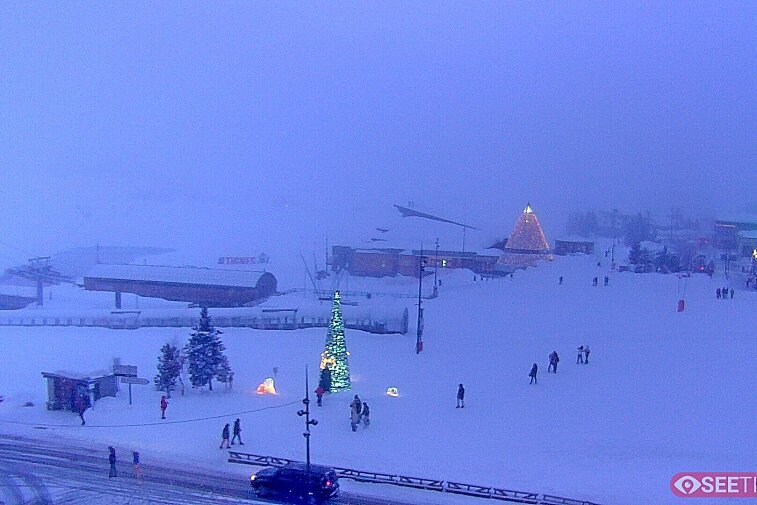
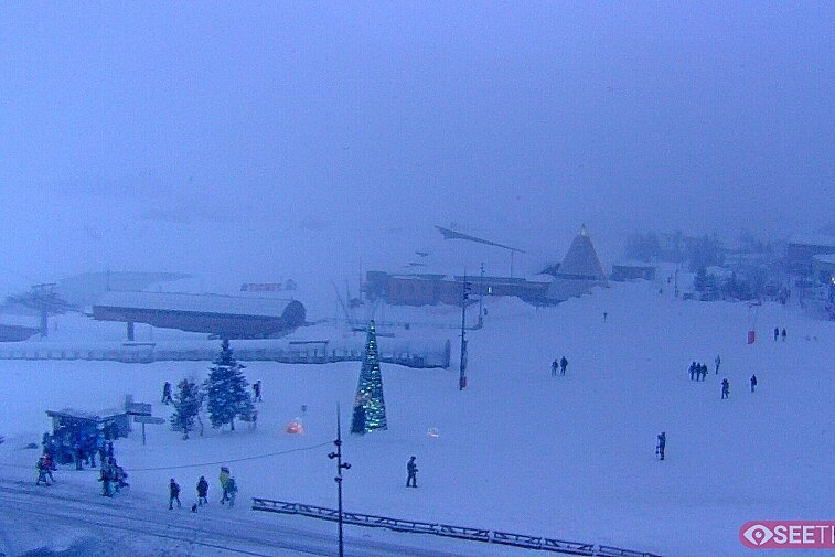
Superb panoramic views over the expansive Tignes ski area and Espace Killy. The camera is situated at the Hotel Le Refuge, in the centre of Tignes Le Lac.
This is a webcam view of the centre of Tignes Les Lac, at the foot of the Palafour pistes and the start of the Aeroski bubble.
Find out what's happening in Tignes and how to make the most of your time here. The latest news, reviews, current events and the trendiest restaurants, as well as interviews with leading locals, insider's guides and things to do, see and experience in the region. Plus, during the winter season, our famous snow reports and dump alerts, all in the same place.
See allLatest News & ReviewsTignes hosts a wide range of events throughout the year. There is a constant barrage of live music après-ski throughout the winter, as well as the much anticipated Live in Tignes festival each April. In the summer, the resort plays home to some major trail running events, such as the High Trail Vanoise in July and the Tignes Trail in August.
See allUpcoming Events

![a picture of a hotel suite at [itemref]](https://cdm0lfbn.cloudimg.io/v7/_images_base_/image_uploader/photos_e2/original/campanules-174-suite.jpg?ua=1766578616&p=listing_summary_middle)